Canadian Flood Information
Ultimate Guide to Canadian Flooding
(Updated April 2021)
Welcome to our Ultimate Canadian Flood Guide!
Here, we cover important topics related to Canada's historical flood situations, the current flood landscape, municipal preparedness and economic implications.
Feel free to dig in & jump to whatever topic interests you:

The History of Canadian Flooding
The History of Flooding
Floods have been around for thousands of years, all the way back to the earliest civilizations. For example, there was Mesopotamia in the Tigris and Euphrates river valley, and Egypt in the Nile River valley. Floods were an integral part of life in these areas, as they deposited fertile silt on the river banks, and irrigated and enriched crops. The resulting effect of this was an increase in crop yield and more land for farming.
However, post World War II, flooding began to take a serious economic toll.
In an article in Procedia Economics and Finance, professor Dobrovic writes, " Since the early 20th century to the present day, there is a significant increase in the extent of damage caused by natural disasters. Only for the period since World War II has the total average amount of damage per decade increased almost tenfold."
The reasons for this were primarily due to the increase in urbanization and residential zones in flood-prone lowlands. Fortunately, mankind's technology improved and we found ways to stem the tide of flooding...to an extent.
Canada's Flood-Prone History
Flooding is part of Canada's natural environmental process.
Historically, flood disasters have been caused by snowmelt runoff, storm-rainfall and flash flooding, ice jams, natural dams, coastal flooding, storm surges, hurricanes and tsunamis.
Between 1900 and 2020 there has been over 250 flood disasters in Canada.
In the next article, we review the worst floods in Canada's history.
The costliest natural disaster in Canada goes to the 2013 Alberta floods, which
caused an estimated $5 billion dollars in damages.
Historic Flooding in British Columbia
- The largest occurred in May 1894, when river waters flooded the area between the Harrison River and Richmond due to snowmelt. The second major Lower Fraser flood occurred in the spring of 1948.
- In 1972, flooding on the Fraser incurred $5–10 million in damages, hitting the upstream communities of Prince George and Kamloops the hardest
Historic Flooding in the Prairie Provinces
- Heavy rainfall in the spring of 2005 caused several rivers to flood in southern Alberta, including the High, Bow, Elbow, Oldman, and Red Deer rivers. Over 7,000 people were evacuated from these regions. Costing an estimated $400 million in damages, it was one of the most expensive disasters in the province’s history.
- In 2010, the same region of Alberta, along with the southern portions of Saskatchewan and Manitoba, experienced one of the wettest springs and summers on record. Saskatoon, for example, received 645 mm of rain between April and September, breaking a 1923 record of 420 mm. Just over 2,000 people were evacuated over the course of the season, according to Public Safety Canada. This led 15% less wheat to be harvested than in 2009. In Calgary, estimates of the total cost ran as high as $6 billion, and the $1.7 billion paid out by insurers rivals the damages incurred during the ice storm of 1998.
Historic Floods in Manitoba
- In 1950 one-sixth of Winnipeg was affected by a flood, and more than 100,000 people had to be evacuated.
- May 1997-Red River Flood: The flooding of more than 1,800 km 2 of land resulted in the evacuation of nearly 30,000 Manitobans. Some 7,000 troops were mobilized to assist civil authorities.
Historic Floods in Ontario
- In October 1954, heavy rains associated with Hurricane Hazel caused flooding on the Don and Humber rivers in Toronto and resulted in more than 80 deaths and severe damage.
- In May 1986, flooding on the Winisk River near Hudson Bay destroyed the Weenusk First Nation town site and killed two people.
- The Great Lakes have been hit by major floods when storms and high water levels coincide. Over the years, damages due to shoreline flooding and erosion have incurred hundreds of millions of dollars in damage.
Historic Floods in Quebec
- The St. Lawrence River presents a risk of flooding in the winter due to ice jams, which are dams created by a natural buildup of ice fragments. These types of floods occurred in 1886 and 1965, costing Montreal millions of dollars in damages and killing five people in communities downstream of the city.
- Heavy rain from thunderstorms in Montreal in July 1987 created a flash flood that cut off power to much of the city, flooded at least 40,000 homes, and killed two people.
Historic Floods in the Atlantic Provinces
- In 1902, 15 ice jams in the Saint John River basin caused severe floods that killed two people in addition to damaging transportation infrastructure and sawmills.
- In 1936, flooding from 22 ice jams caused even more widespread damage at a cost of approximately $2 million.
- New Brunswick has been affected by flooding related to several extreme weather events: Hurricanes Edna (1954), Gladys (1968), Belle (1976), as well as Tropical Storm David (1979).
Historic Floods in the North
- In May 1979, 80% of buildings in Dawson City were flooded by an ice jam on the Yukon River, and cost approximately $1.85 million.
- In June 2012, a combination of rain and snowmelt flooded Upper Liard, Yukon, as well as areas of northern BC and western Northwest Territories, with estimated total damage at $1.5 million.
- In early May 1989, ice jams caused flooding on the Liard River, incurring $1.1 million in damage to the area around the hamlet of Fort Liard and the town of Hay River, in the south of the territory.
Flooding in Canada Today
In 1975, the federal government launched a program to minimize flood damage. The
main outcome of this is that a flood map of high risk areas was produced. This was the first major step that the country took to reduce the devastating effects of flooding. The flood risks maps allowed people to be aware of how and where they should build of tear down.
More recently, urban flooding can be caused by stormwater runoff, riverine flooding and structural failure when engineered flood management structures, including dams and levees, prove inadequate to manage the quantities and force of flood waters.
Currently, damages related to flooding are increasing due to several theoretical causes, one being climate change, and the other being population increase and urbanization.
The Hamburg University of Technology gives a great overview of the effects of flooding, from the immediate to the long-term effects:
"Immediate impacts of flooding include loss of human life, damage to property, destruction of crops, loss of livestock, non-functioning of infrastructure facilities and deterioration of health condition owing to waterborne diseases."
Flooding in Canada: On The Rise
According to the Canadian Data Database, the number of floods have almost tripled since the 1960's and continue to rise today. Climate change is making flood risk much prevalent. A rise in temperatures mean more runoff and rainstorms, which means more flooding. Statistics show that the number have floods in Canada have almost tripled from the 1960s to the 1970s and continue to rise today. According to scientists, the 21 st century will present Canada with the worst flooding Canada has ever seen.
As the threat of flooding increases in Canada, citizens must take extra precautions to stay safe, prepared and educated:

The worst floods in Canadian History
THE WORST FLOODS IN CANADIAN HISTORY
Millions of dollars lost, towns obliterated, lives taken; Nearly every province in Canada has been deeply impacted by severe flooding.
Here are 5 of Canada's worst instances of flooding:
1. Red River Flood of 1997
The Red River flood was the result of heavy snowfall & extreme temperatures and affected the Red River areas across Canada and the United States.
The City of Winnipeg, Manitoba, was hit the hardest, causing $500 million in damage to property and infrastructure and evacuating 28,000 people from their homes.
With cresting of 21.6 ft (6.6 m), the flood water approached Winnipeg at a speed of 138,000 cbf/ second (equivalent to the amount of water in an Olympic-sized swimming pool every second).
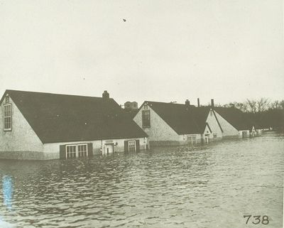
2. Winnipeg Flooding of 1950
Heavy snow cover created one of the worst floods in Manitoba’s flood-prone history.
The Red, Norwood, East Kildonan and Fort Gary rivers to rose to dangerous
levels. Powerful currents crushed dikes, causing uncontrollable flooding.
Citizens in Winnipeg were faced with 4.5 meter deep floodwater, which resulted in
60,000 people having to evacuate their homes.
Around 5,000 Canadian army, air force, and navy men came in to set up impromptu dams just to try and safely evacuate citizens. They brought in 1,200,000 sandbags and over one million pounds of equipment.
Although just one fatality occurred, the people of Winnipeg still felt the great repercussions of this horrible incident.
Winnipeg's flood of 1950 cost the city about $126 million dollars (adjusted for 2020) and damaged 10,500 people's homes. This city was basically submerged under water because of this great flood.
3. Manitoba Flooding of 2009
The 2009 flood was the second worst in Manitoba's history since 1826.
Caused by heavy rainfall in combination with already over saturated soils from the
previous winter, this spring flood devastated the civilians of Manitoba.
To make things worse, ice jams raised the Red River to record levels (just barely lower
than the record height set in the Winnipeg flood of 1997).
Many of the hundreds of civilians were not able to return home for weeks due to the debris. Many also were never able to return home because their home was completely destroyed.
4. Assiniboine River Flood of 2011
Caused by above-average precipitation in Western Manitoba and Saskatchewan, the Assiniboine River flood was classified as a 300-year flood (meaning it occurs once every 300 years).
The Assiniboine River caused the most severe flooding in 2011, reaching its highest level of 37,100 cu ft/s (1,050 m3/s). This was 60% higher than the peak record in 1923.
In some areas, the river was about 30 times wider and several meters higher than normal. The flooding lasted 120 days and caused the province of Manitoba to declare state of emergency in 70 communities.
During this flood, 850 roads were forced to close, and 1,800 Canadian military members were part of the battle effort against the devastating flood. The Canadian government spent close to $1
billion on flood relief and compensation.
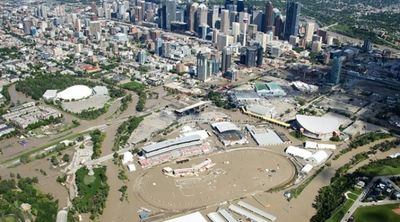
5. Alberta Floods of 2013
The heavy rainfall in June 2013, combined with the melting snow-pack of the Rocky mountains, caused one of Canada's fastest instances of flooding in recorded history. 32 separate municipalities declared states of emergency due to the rapidly rising water levels. 2200 Canadian military troops were sent in to aid in cleanup, as the manual labor required far exceeded the available manpower. Five lives were lost, and an estimated 5 billion dollars in damages were suffered. Of that 5 billion, only 1.7 billion were insurable damages - further illustrating the great need to supplement your insurance with personal emergency preparedness supplies.
In November 2013, the Government of Alberta funded preventative projects to mitigate future flooding within Calgary and High River - construction of a channel to divert water around High River and a dry dam for the Elbow River west of Bragg Creek.
6. Thunder Bay to Montreal Floods of 2012
The heavy rainfall of 108 millimeters in the City of Thunder Bay in northwestern Ontario damaged the main pumping station of the city. It led to numerous infrastructure damages, basement flooding, closed roads, and the inability of homeowners to flush water out.
There have been stories of residents having a flood level up to their knees in their basements. Railways, roads, and the Northwood Mall were also flooded out.
The destruction done by the floods could not be instantly prevented as the floods were extremely weather dependent. This has led communities to have to wait 24 hours to see what happens before they take the next steps.
7. Southern Ontario Flash Floods of 2013
The storm and flash flooding of more than ninety millimeters of rain became known as “the wettest moment in Toronto’s history.” A GO Train was stranded by floodwaters and cars were
abandoned during the 126 millimetres of rain recorded at Pearson International Airport.
The destructive downpour destroyed roads, transportation facilities, and basements. Thousands of Ontario residents went to bed without electricity that night.
Ontario homeowners have suffered substantial losses on their properties where insurance does not come close on covering the actual expense of damages. This has forced many residents to look for a new home as they could no longer cope with more potential devastation.
8. Quebec Floods of 2017
The combination of torrential rainfall and melting snow following the increase in temperature fueled the severe floods suffered by the City of Montreal. The worst-hit areas of Quebec are also
the most famous for their beautiful scenery and convenient access to the water.
Having a surge of seven feet of water crashing into homes within five seconds overwhelmed the foundation of the home, creating permanent costly damages. 1,900 homes have been damaged, resulting in $150,000 worth of loss per home. However, several homes in the area were so severely affected that they needed to be completely destroyed.
Laws have been passed to restrict the homes to be built on flood plains in order to avoid the potential destruction caused by the reality of an increase in future floods. The economic and emotional consequences tied to torrential rainstorms are hard to be prevented.
Conclusion
It is obvious that the floods in Canada have been getting worse each year. It is clear that the risk of flood destruction is particularly high as Canada’s temperature increases rapidly affecting heavy rainfall.
The effects of severe flooding weaken the sense of comfort of Canadians, because floods will arise at any time of the year. It is anticipated that the severity of flooding will escalate, forcing Canadian residents and their government to take drastic preventive steps.
Undoubtedly, extreme floods are the costliest and most devastating natural disaster for Canadians.
However, by anticipating the outcomes of each season, citizens can be better
equipped with the resources needed to overcome all the challenges that come with floods.
Flood Protection Tools:
Flood Barriers
QUIK-RESPONSE ™ Self-Expanding Sandbags
Sandbag Calculator
How many sandbags do I need to build a flood barrier?
Flood Damage Cost Calculator
What Causes Flooding in Canada?

10 Common Causes of Canadian Flooding
Canada's flood-prone history is large in part due to rapid changes in water levels of lakes, rivers and coastal oceans. However, central provinces, such as Alberta, are greatly affected by snow-melt and storm water flooding.
By understanding and identifying the causes of Canadian flooding, citizens can prepare for what scientists are saying is inevitable: a severe increase in the frequency of future flooding.
Here are 10 of the most common causes of overland flooding in Canada:
1. Heavy Rain
Heavy rainfall poses a huge flood risk for Canadian municipalities.
While municipal drainage infrastructure usually functions well, heavy rainfall can overwhelm these systems and cause mass overland flooding.
And, with Canada's history of prolonged heavy rainfall, its no surprise this is the main culprit for Canadian flooding.
2. Overflowing Rivers
Five of the worst floods in Canadian history were caused by over flow from notorious Red River in Manitoba.
Adding to the case, BC experiences flooding from rising water levels of the Fraser River, and some of the worst floods in Alberta's history has been caused by the Oldman River.
3. Ice & Snow Melt
Canada is famous for its long, harsh winters.
Unfortunately, this is the perfect recipe for spring flooding.
All that snow and ice have to go somewhere, and usually the resulting run-off goes to low-lying areas around the mountainous areas. .
4. Overwhelmed Urban Drainage Basins
Canada's large urban centers are huge paved sprawls.
As expected, pavement isn't very permeable, meaning floodwater wont be absorbed by the ground and needs to flow into drainage basins.
When municipal drainage basins over-fill, municipal flooding occurs.
5. Geography
Unfortunate geographical location plays a huge factor in flooding, especially in Canada.
In many provinces, governments are now putting restrictions on building in flood plains and food-prone areas.
Municipalities located near rivers, lakes, oceans, river bottoms and low lying plains are especially at risk.
6. Channels with Steep Sides
Flooding can occur from fast runoff into lakes, rivers, dugouts and reservoirs.
This is often the case with rivers and other channels that feature steep sides, and the resulting rapid rising water-levels can cause severe overland flooding.
7. A Lack of Plant-Life
Vegetation is crucial for slowing runoff and preventing flooding. They act as natural flood barriers.
Lack of vegetation has been increasing because of more and more
infrastructure being built. This has contributed to more floods in urban areas.
With the absence of vegetation, there is a much higher chance that heavy rainfall and rising water levels will cause overland flooding. .
8. Broken Dams
Aging infrastructure is usually replaced without incident. However, aging dams that fail to perform in crucial moments have caused some serious flooding.
Dam failure was responsible for the Mount Polley incident in 2014.
Furthermore, experts fear the Montreal Dam is at risk of failing as well.
9. Over- Saturated Soils
Soil can only absorb so much water before it becomes over saturated.
Once this occurs, the water (in many cases) has nowhere else to go and begins to pool. This is commonly seen on farmland during heavy rainfall.
10. Mountainous Terrain
Mountains or steep hills can increase flooding for low-lying municipalities.
Both rain and snow melt can rapidly ascend from mountainous terrain and quickly overwhelm sewage and drainage systems.
Conclusion
Now that you have learned about the top 10 causes of flooding in Canada, it is important to know how to protect yourself from flooding.
Many of these are uncontrollable causes but some you can prevent by doing things like planting vegetation and building in low-flood risk areas.
Check out this article to find out more ways to protect your property:
CANADA'S MOST FLOOD-PRONE CITIES
Wondering which Canadian cities are most prone to flooding?
Floods are the costliest natural disaster in Canada and they can occur at any time of the year. Whether caused by rapid snow-melt, heavy rainfall or rising rivers, floodwater damages have cost Canadian municipalities billions of dollars annually.
Canada's Most flood Prone Cities:
Calgary, AB
Calgary is situated where two mountain rivers (Bow and Elbow rivers) meet
and hence is at high risk of flooding.
Calgary has experienced the worst recorded flooding in Canadian history since 1879. Large floods have occurred time and again in 1879, 1897, 1902, 1929 and 1932. The most recent one was in 2013 which occurred due to heavy rainfall on melting snow in the Rocky Mountains.
During this 2013 flooding, over 122,000 Calgarians were forced from their homes, the city
incurred billions of dollars in damages and the post-flood cleanup took years.
While remaining relatively flood-free for the last 6 years, researchers predict that Calgary still faces a 30% chance of experiencing an even greater flood before 2050 as cities grow and establishments develop in the river valleys.
Montreal, QC
Since the 1990’s, Quebec has witnessed a major flood nearly every year.
Flooding mainly occurs in spring due to snowmelt, in summer due to heavy rains and in winter when ice forms and blocks a stream or river.
Montreal monitors the water levels of the St. Lawrence River, the Rivière des Prairies, Lac Saint-Louis and Lac des Deux Montagnes constantly along with weather forecast during high-risk period such as spring and winter.
In 2015, over 150,000 homes were left without electricity for several days due to mass floods and the 2019 flooding cost Montreal $17 million.
Households living in and around the areas on the shores of Lac des Deux Montagnes and the Rivière des Prairies are at a higher risk of flooding than those on the shores of St. Lawrence River and Lac Saint-Louis.
Check whether you live in a flood-prone zone using the flood maps published by the Quebec government.
Winnipeg, MB
Winnipeg is notorious for its freezing cold winter temperatures. Yearly thaw-cycles combined with heavy rains pose serious flood problems for the citizens of Winnipeg.
The citizens of Manitoba have been witnessing major floods since the 1800’s.
The Red River and Assiniboine River basins have been extremely vulnerable to flood and since Winnipeg is at the intersection of these two rivers, it has been exposed to substantial damage over the years.
In 2014, Winnipeg experienced the coldest winter on record since the 1800's.
Halifax, NS
Halifax, the capital of Nova Scotia is an Atlantic Ocean port that is at a higher risk of
flooding due to hurricanes and rising sea-levels.
During the coming century, Halifax Harbour’s level is expected to rise by twice the historical rate and faster.
Most recently, Hurricane Dorian touched down in Nova Scotia in 2019 and the resulting floods left more than 207,000 people without power.
Areas such as Tufts Cove and Shannon Park are more vulnerable to flooding in the Halifax
region.
St. Johns, NL
The Newfoundland and Labrador Municipal Affairs states that 72% of floods that occurred since 1950’s were due to rainfall events, followed by coastal flooding which causes 17% of the flood events.
The risk of flooding has been rising over the years due to increasing population density around water bodies and have resulted in over $267 million in damage over 64 years.
Blizzards in St.Johns create somewhat unmanageable flooding once the snow thaws. Because of this, St. Johns has consistently been a flood-prone city in Canada.
Most municipal government websites have published flood map to help you assess the risk your home is exposed to and help you better prepare in case of a flood.
Conclusion
These cities are just some of the most flood-prone areas of Canada.
As mentioned before, floods are the number one costliest disaster in Canada. It is important for citizens to be informed and prepared to face the worst expected floods possible.
In order to stay safe, check out flood zone maps to see if your residence is at risk for flooding and prepare with sandbags for flooding.
Wondering which Canadian cities are best prepared for flooding?
The Costs of Canadian Flooding
The Real Costs of Canadian Flooding
$673 million a year.
That is how much money Canadian tax payers pay each year for flooding costs alone.
The damage a flood causes are far beyond just the dollar sign though.
Businesses are destroyed, precious possessions are swept away, lives are lost. The costs of a flood are deep and they just don’t go away in a few weeks….
Let's dive into the REAL costs of flooding:
- The average cost of damage by just 1-inch of water in an average-sized home is $34,812
- Economic Impact: Flooding costs Canadian taxpayers $673 million per year
- Only 6% of Canadians living in designated flood-prone areas are aware of their flood risk
- Only 34% of Canadians are insured for overland flooding
- Less than 30% of homeowners use flood protection measures
The Economic Impacts of Flooding On The General Public
Flooding is one of the largest expenses for disaster assistance compensation programs in
Canada.
In this article, we discuss the financial impacts of flooding on the general public and how they can try to mitigate the burden.
There are two types of flood impacts:
Direct Impacts
Insurable Losses
The amount of money spent on insurable losses varies depending on the extent of flooding, property type impacted, individual insurance policy, and political circumstances. Worth noting, overland flooding is not included in most flood insurance in Canada.
Temporary or Permanent Loss of Business/Wages
Businesses are forced to shut down in order for floodwaters to recede and for the area to be considered safe to re-enter. This causes an overall loss of business and hence the overall economy of that area gets hit.
The impacts of flooding are devastating for any region and the economic losses prove damaging to the overall economy and well-being of citizens.
Indirect Impacts
Loss of livelihoods
As communication links and infrastructure such as power plants, roads, and bridges are
damaged and disrupted, economic activities come to a standstill, resulting in a dysfunction of normal life for a period much beyond the duration of the flooding.
Decreased purchasing and production power
Damage to infrastructure also causes long-term impacts, such as disruptions of clean
water and electricity supply, transport, communication, education, and health care. This can often lead to increased vulnerabilities of communities living in the area.
The additional cost of rehabilitation, relocation of people, and removal of property from flood-affected areas will increase the costs overall, making it difficult to rebound after severe damage has occurred.
Hindering economic growth and development
The high cost of relief and recovery may adversely impact investment in infrastructure and other development activities in the area and in certain cases may cripple the frail economy of the region.
In addition, recurrent flooding in a region may discourage long-term investments by the government and private sector alike, as well as loss of resources that can lead to high costs of goods and services, delaying its development programs.
In contrast to the economic losses experienced in the event of a flood, recovery and rebuilding efforts can recuperate lost revenue and/or business that occurred during the flood.
Four preconditions are essential to establishing a strong flood risk management culture:
- There must be accurate and up-to-date flood hazard mapping, available through the monitoring systems, to allow all tiers of government – as well as insurers, developers, and other key private sector stakeholders – to make smart decisions about asset management, urban planning, and flood risk management and monitoring;
- There must be ongoing and adequate investment in flood defenses, and sewer and storm water infrastructure, much like how the U.S. government is working to implement better policies for dealing with environmental disasters;
- There must be widespread awareness of flood risk and a sound understanding by all stakeholders – including governments, communities, and individuals – of the physical and financial consequences of flood risk and the tools available to ensure Canadians are prepared;
- To reduce the financial burden on taxpayers, individuals should repair flood damage with their own incomes. This would also limit the individuals dependence on the government, which has previously proven to be not as effective.
Implementing the above strategies will aid in bettering the efforts for managing climate change, especially when efforts to slow it down are not as effective.
Although these strategies seem easy in theory, they are actually difficult to practice, hence why flood mitigation efforts have not been as successful in the past.
The Canadian government’s efforts are not as effective as they could be, and with the rise of flooding, it is becoming harder and harder for people to protect themselves and their properties.
Order online: Sandbags for sale in Canada..
Household Flood Water Damage: A Closer Look at Costings

What Are the Costs of Household Flood Water Damages?
Over the years, hundreds of thousands of Canadians have been affected by floods and with the rising global warming threat, it shows no signs of respite.
Water damage to the house caused by flooding can turn out to be an extremely expensive affair to the homeowners.
The Insurance Bureau of Canada has estimated that it would cost an average of $43,000 to repair a flooded basement.
In this article, we address what kind of repairs and restoration homeowners can expect after a flood and how much is that likely to cost them?
For an average house size of 2500 sq. ft, homeowners can expect to incur anywhere between $34,000 - $50,000.
In order to understand the extent of damage, homeowners may need to inspect three sets of cost:
- Water extraction and clean up
- Structural repairs and
- Replacement of personal property, equipment and appliances
Cost of clean-up
Without proper precautions in place during a flood, there is a high possibility that water floods the basement which would require a proper clean-up by professionals. It would require pumping out the basement using vacuums and suction followed by drying the basement using specialized ventilation systems. If this process is not done properly, water could seep into every space and cracks leading to mold infestation.
The cost of cleaning the basement could range anywhere between $7 and $10 per sq. ft.
depending on the extent of damage, size of the area damaged etc.
Drywall
Since the drywall is porous, when exposed to water it can lose structural integrity. If
left untreated, the drywall might deteriorate over time and slowly sag, thus requiring
replacement. The paper backing the drywall can even become a perfect habitat for mold or mildew.
Depending on the extent of the damage after the flood, it may require restoration or
replacement. The cost of replacing drywall could be $2 per sq. ft. with hourly labor rate of $50 to $75.
Mold remediation
If the basement and house has not been dried thoroughly, there is a high
chance of mold or mildew infestation as mold grows quickly aided by damp environment
affecting the structure of the building and the health of you and your family.
The cost of mold remediation depends on the size and the location of the mold infestation.
For small areas of the house such as crawlspace it could cost anywhere between $500 - $3,000 and for complicated areas such as wall ducts or attics, the cost can run north of $4,000.
Hardwood floors
Whether hardwood floor requires repair or replacement depends on the
severity and duration of water exposure after the flood. If hardwood floor is submerged in
standing water, it most likely would require replacement.
Hardwood floors are typically priced between $7 to $10 per sq. ft. plus labor costs.
Carpet
If the damage is severe enough to warrant hardwood floors replacement, then the
carpets will need to be replaced too and it is estimated to cost approximately $4.7/sq. ft.
Personal property
In addition to the above repair and replacement, homeowners have to bear the cost of replacing personal properties such as equipment, furniture and appliances.
While not everything might require replacement after the flood, some areas of the house such as ceilings and walls can most likely be repaired but hardwood floors and carpet may require replacement.
The best way to mitigate the risk is to be prepared with an effective flood protection barrier. Online sandbag delivery is a convenient way to get flood protection delivered right to your home.
Global Warming's Impact on Canadian Flooding

GLOBAL WARMING & FLOODING: HOW THEY ARE RELATED & HOW TO PREPARE
Canadian flooding causes billions of dollars in annual damages, with research showing that the frequency and intensity of floods will continue to increase.
Precautions must be taken to protect our homes, infrastructures, and roads.
In this section, we’ll explain why global warming is important, how it's affecting Canadian flooding, and what you can do to prepare for it.
Why Does Global Warming Matter?
Canada is warming up faster than the rest of the world, according to Canada's changing climate report.
Our entire planet is experiencing the effects of global warming- warmer winters, melting glaciers, and extinction of species.
While small incremental changes to the Earth’s temperature may not seem like a lot, it poses a higher risk than we think.
Our future is on the front lines of global warming; urging us to make smarter choices to preserve our environment.
Global Warming is contributing to flooding in Canada
Between 1948 and 2016, Canada experienced an annual temperature increase is 1.7 degrees Celsius as a whole, and 2.3 degrees Celsius for Northern Canada.
Increases in temperature fuels the rise of sea levels; thus increasing the risk of flooding.
In fact, at the time of writing this article (April 2020), 15,000 people in Canada are currently evacuating their homes due to rising rivers caused by ice jams.
Homes and roads are destroyed leaving people boating to find shelter and searching for lost pets.
Extensive rainfall has also been linked to the increased hurricanes caused by Global Warming, further contributing to flood situations.
As global warming increases flooding in Canada, how can we prepare?
Simply put, both Canada's government and its citizens need to take greater proactive initiatives to combat the increasing prevalence of flooding.
And, according this infographic, flood damages are only going to get worse.
This means failure to adapt will result in further billions of dollars in damages for Canadian residents, government and insurance providers.
While there are several options to take proactive measures, here are the top four suggestions to help you prepare for flooding caused by Global Warming:
- Utilize flood barriers. Sandbag barriers (or more recently, sandless sandbag barriers) are the most effective and common way to defend properties from flooding.
- Install flood vents. Flood vents help reduce structural harm caused by floods. The permanent openings enable the water to flow in or out of the outer walls of the building’s base without damaging the whole framework.
- Plant extra vegetation to retain excess water. Adding these types of vegetation around your property adds additional protection to your home from flooding. They absorb, disperse and prevent floodwater from pooling on your property.
- Build stronger man-made dams. Man-made dams built in Canada have primarily been used for drainage, water supply, or flood protection purposes. It is important to enhance their efficiency without distorting the normal rhythms of the ecosystem.
Global warming is a growing issue that cannot simply be ignored anymore.
Society must take extra measures in order to preserve the environment not only for themselves, but for the entire ecosystem and the future of upcoming generations.
Melting glaciers and rising temperatures are the major sources of intense flooding in Canada.
A warmer atmosphere holds more moisture which leads to an increase volume of rainfall.
This results in excessive rainfall that cannot be stored into land, inundation of waterways, and high tides, all of which contribute to the worsening annual flood problems that Canadians continue to face.
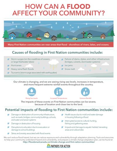
Flood Impacts on Canadian First Nations Communities
Potential Flood Impacts on First Nations Communities
Did you know that First Nations communities are most affected by flooding?
Why?
Because their communities are in the flood-prone areas such as shorelines of rivers, lakes, and oceans.
Flooding can cause devastating property & financial loss for First Nations communities, its citizens and its leaders:
Damage or destruction of community infrastructure
Roads, bridges, community buildings, schools, and water and sewer systems are examples of infrastructure that can be damaged by the flood water. If they are not properly repaired from the damage, this can affect an ability to commute within the First Nations areas. On top of this, many reservations have unpaved roads that are heavily damaged by floodwater. This makes it difficult to administer assistance and repair the damges
Damage or destruction of housing
Rapid flooding can cause significant damage to the First Nations’ properties if they do not have effective prevention measures in time to block their house entrance from the flood water.
Disruptions to education due to evacuation or damage to school buildings
If the First Nations Communities do not have proper measures to drain flood water, this will disrupt the education in the community since school buildings are damaged and students cannot transport to school.
Stress and anxiety associated with flood events
Flooding not only causes physical damage to the community, it also creates anxiety and frustration to the people in the areas since it is hard for them to perform their daily activities.
Health issues following a flood
If there is no effective way to drain water in the communities, community members will be exposed to water-borne disease or infection such as wound infections, diarrheal diseases, and hepatitis A and E.
Interrupted access to cultural, hunting, fishing and gathering areas
Flood water will prevent First Nations from social gathering and performing their normal activities such as hunting and fishing. This can lead to food supply problems in the communities as well.
Impact to aquatic habitat, harvesting areas, and cultural sites
It is not surprising to say that aquatic habitat will be disrupted from the flood water. Harvesting areas are also damaged, affecting the ability to grow and harvest crops of the First Nations Communities.
Common Sources of First-Nations Community Flooding
Storm surges
Storm surge is an unusual increase in the seawater level during a heavy storm. The surge, caused by the strom’s winds, pushes water into the shoreline and can lead to coastal flooding.
Hurricanes
Hurricanes can be a threat to massive coastal area flooding since they produce large amounts of heavy rains in the areas.
Heavy rainfall/ flash floods
Canada has a prolonged history of heavy rainfall. The sustained heavy rainfall can generate flooding if it is not effectively drained. This poses a threat to First Nation Communities.
Tsunamis
Tsunamis are a sequence of long high ocean waves due to an earthquake or landslides. These ocean waves can flood the land area for several hours once it reaches the shore. Tsunamis is one of the deadliest natural disasters since it had killed and injured thousands of victims around the world in the last decade.
Infrastructure Failure
Failure of dams, dykes, and other infrastructure (bridges, culverts, storm water systems)
Ineffective of engineering and city planning can lead to the failure of the First Nations communities’ infrastructures, causing the flood in the areas.
Ice jams
Ice jams are big ice chunks formed on a river that can block the flow of water. They pose a major flood risk to First Nations communities located along rivers.
Snow melt
We all know that Canada is famous for having a long winter. Heavy snow from the winter and the subsequent ice melt in Spring plays a major role in flooding in First Nations communities.
As the climate is changing, we can expect that the flooding situation among First Nations communities can get worse. This is evidenced by the continuously rising sea level, increased temperatures, and extreme rainfall. By using flood mitigation measures, such as sandbags for flooding, First Nations communities can minimize damages.

How to Claim Disaster Assistance in Canada
What is the Disaster Assistance Claims Process in Canada?
The Canadian Government responds to the financial needs of provinces and territories created in the wake of major natural disasters, such as overland flooding, through their Disaster Financial Assistance Arrangements (DFAA).
The process of disaster claims can be confusing, as several forms of assistance are available from federal, provincial and territorial levels of government.
These address certain disaster-specific needs and aid in specific economic and social sectors as well.
Canadian Disaster Assistance Claims Process for Homeowners:
- Province/Territory declares the event is eligible for disaster assistance- usually meaning the event caused sudden, unexpected and widespread damage and losses that are beyond the ability of individuals to manage on their own. The event cannot be the result of negligence or deterioration of infrastructure.
- Homeowner documents damages and gets quote on repairs (applicable only if home is located in the eligible disaster area).
- Disaster relief covers only basic items and returning your primary residence to pre-disaster condition. Most coverage will include meals and accommodations if you need to leave your home. Many luxury items are not covered, and there are often upper limits on how much you can claim for home contents (eg. home appliances).
- Homeowner submits claim to insurance and receives a letter with details on the type of loss/damage, the amount covered by insurance, and the insurer's reason for not covering any amount. Most provinces and territories will not cover your losses if flood insurance was reasonably and readily available in your area, even if you have not purchased coverage yourself.
- Homeowner submits claim to provincial/ territorial ministry responsible for the program.
- Ministry processes your claim and sends an adjuster to property if further information is required.
- Claim amount (insurable items only) determined (minus insurance, deductibles and any non-government support you may receive, such as Red Cross or fundraising assistance).
- Claim amount is paid to applicant.
How to protect your home from flooding?
Our complete Flood Safety Guide contains everything you need to know to effectively protect your home from flooding.
Canadian Overland Flood Insurance

What Exactly is Canadian Overland Flood Insurance?
Overland flood insurance is an insurance option that insures a water-damaged home.
The water must be caused from intrusive floodwater that entered through doors & windows and was caused by overflowing lakes, rivers, ponds or storm water.
Usually, overland flood protection is not included in a normal home insurance policy, so be sure to inquire about it with your insurance provider.
Is your home at risk of flooding?
Check out the most common ways that flood water can enter your property and how to stop it.